 |
16th Street Walking Trail |
County:JeffersonCity:BirminghamLocation:16th Street Linear ParkDescription:1/2 mile pedestrian trail located in a 2.3 acre park along 16th Street. |
Map Links: |
||
|
Satelite view (Map of all trails) 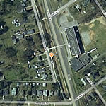
|
Google Birds-Eye-View (Directions) 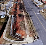
|
Google-street-view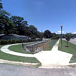
|
Total Miles:1/2 mile |
|
Surface Type:Concrete |
|
Primary Use:Walking |
|
Trail Hours:6 am - 9 pm |
|
Directions to Trail:North US Hwy 31 (state Hwy 3) take ramp and go North I-65; exit 250 take ramp and go North east on I-459 exit 27 take ramp to county Hwy 143 to county Hwy 74 turn left county (Rd 64).The 16 th Street Linear Park; the trail is behind the Park. |
|
Latitude:33.534594Longitude:-86.709837 |
|
Who’s responsible for Trail? | |
Organization:City of Irondale |
|