 |
Black Creek Trail |
County:JeffersonCity:FultondaleLocation:Black Creek ParkDescription:1 mile diversified trail that extends along the CSX rail bed from Black Creek Park to a proposed soccer complex in Fulton. |
Map Links: |
||
|
Satelite view (Map of all trails) 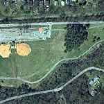
|
Google Birds-Eye-View (Directions) 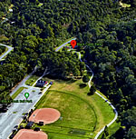
|
Google-street-view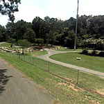
|
Trail Website:Fultondale Parks |
|
Total Miles:1 mile |
|
Surface Type:Asphalt |
|
Primary Use:Cycling, Walking/Jogging |
|
Trail Hours:Always open |
|
Directions to Trail:65 North exit 276 turn right at exit follow Walker Chapel Road Main Red light to HWY.31 crossed over stay straight. Take a left at Yarbough Rd. the park on the right. |
|
Latitude:33.621359Longitude:-86.796928 |
|
Handicap Accessibility? |
|
Trailhead:Yes |
|
Entire Trail:Yes |
|
Who’s responsible for Trail? |
|
Organization:City of Fultondale |
|