 |
Jemison Park Nature Trail |
County:JeffersonCity:Mountain BrookLocation:Mountain Brook ParkwayDescription:Located on an 54 acre area designed as a green way, the trail is used by many for a walk, jog, picnic or just to enjoy nature and Shades Creek. |
Map Links: |
||
|
Satelite view (Map of all trails) 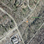
|
Google Birds-Eye-View (Directions) 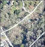
|
Google-street-view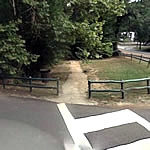
|
GO PRO Videos with Elevation Overlays(best viewed in 720p) |
||
|
Jemison Park Nature Trail (Part of Mtn Brook Greenway System) |
||
|
|
||
Trail Website:Jemison Park Nature Trail |
|
Total Miles:2.5 miles including the connected Nature trail and Watkins Trace Trails |
|
Surface Type:Mostly asphalt with some concrete, gravel and dirt sections. |
|
Primary Use:Walking, Cycling, Jogging |
|
Trail Hours:Always open |
|
Trail Connections:Connects to Mountain Brooks extensive sidewalk system. |
|
Directions to Trail:Two blocks East of highway 280 at the Lakeshore Drive intersection. |
|
Latitude:33.476236Longitude:-86.763545 |
|
Trail Amenities |
|
Picnic Area:- Yes |
|
Handicap Accessibility? | |
Trailhead:Yes | |
Entire Trail:Yes | |
Who’s responsible for Trail? | |
Organization:City of Mountain Brook |
|