 |
Owl Creek Horse Trail System |
County:LawrenceCity:Location:Bankhead National ForestDescription:25 miles of dedicated horse trails in the Bankhead Nat'l Forest Area. From Pine Torch parking and Trailhead to Owl Creek Horse Camp area. Comprised of 3 loop trails. |
Map Links: |
||
|
Satelite view (Map of all trails) 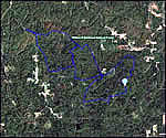
|
||
Trail Website:Owl creek Horse Camp |
|
Total Miles:25 miles |
|
Surface Type:Dirt |
|
Primary Use:Equestrian |
|
Directions to Trail:I-65 exit 334 NorthWest on Hwy 67 (Point Mallard Pkwy SE); left on Hwy 24 (Corridor V) for 17 miles; left on Hwy 33 (Market St); name changes to Wilderness Parkway for 9.3 miles; left on CR-70 2.2 miles; trailhead parking for main Pine Torch trailhead on the left. Other trailheads exist around area; see website pdf map. |
|
Latitude:34.31993676Longitude:-87.28337288 |
|
Who’s responsible for Trail? | |
Organization:USDA Forest Service |
|