 |
Winston County
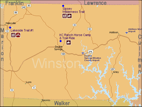
Winston County
Equestrian Trail
Owl Creek Horse Trail System
Description: 25 miles of dedicated horse trails in the Bankhead Nat'l Forest Area. From Pine Torch parking and Trailhead to Owl Creek Horse Camp area. Comprised of 3 loop trails.
Map: Owl Creek Horse Trail System (Google Maps)
Multi-Use / Family Park Trails
Lakeside Trail
City: Haleyville
Description: 1.9 mile multipurpose trail including foot bridges.
Map: Lakeside Trail (Google Maps)
Rocky Ravine Park
City: Haleyville
Description: 140 acre park is made up of walking trails, hiking trails, picnic areas, fishing, waterfalls and full of wonderful things to see in this very serene setting right in the heart of town. Rocky Ravine has a small playground, swings, and is a natural gorge with a flowing stream.
Sipsey Wilderness Hiking / Equestrian Trails
Borden Creek Trail (#200)
Description: Camping, restroom, length 2.7, moderate difficulty scenic trail along Borden Creek with views, waterfalls and a short narrow cave to pass through. One of the more popular Sipsey wilderness trails with ample parking at Sipsey Trailhead at the South end ($3) or limited parking at the Borden Trailhead at the North end (free) and numerous campsites available along trail.
Map: Borden Creek Trail (#200) (Google Maps)
Braziel Creek Trail (#207)
Description: Moderate to difficult trail from the Borden Trailhead on the south ending into the Northwest Trail (#208) about a half mile west of the Gum Pond Trailhead on the north end. At the south end the trail follows along Braziel Creek leading to the north where you find yourself below the jutted rocks near the top of the bluff. The trail features some of the best scenic views of the Wilderness.
Map: Braziel Creek Trail (#207) (Google Maps)
Bunyan Hill Horse and Wagon Trail (#224)
Description: Easy to moderate trail permitting horses and horse-drawn wagons. Accessible from the southern end via the Borden Trailhead and terminating on the northern end into the Northwest Trail (#208).
Map: Bunyan Hill Horse and Wagon Trail (#224) (Google Maps)
Bee Branch Canyon Trail (#204)
Description: Easy hike except one hill near Big Tree. North end branches off Bee Ridge Trail (#204) with the south end accessed from the Sipsey River Trail (#209). Spectacular views with bluffs; waterfalls (usually) and the popular “Big Tree”; the largest Yellow Poplar in Alabama; about 150 feet high and 25 feet in circumference. Some camping spots exist; but better sites can be found at the south end by the river.
Map: East Bee Branch Canyon Trail (#204a) (Google Maps)
Gum Pond Horse and Wagon Trail(#223)
Description: Easy trail from the Brazield Trailhead providing access to the north end of Mitchell Ridge Trail (#210) and the Northwest Trail (#208) on the south end. Horses and horse-drawn wagons are also permitted on this trail as well as the adjoining Northwest (#208) and Bunyan Hill (#224) trails. The main uses of trail 223 tend to be for horseback riding or day-hiking to the Big Tree and for access to trail 210.
Map: Gum Pond Horse and Wagon Trail(#223) (Google Maps)
Lookout Trail (#203)
Description: Moderate trail accessible from the Borden Trailhead or the Flannigan Trailhead. Winds through bluffs and valleys with outstanding views.
Map: Lookout Trail (#203) (Google Maps)
Mitchell Ridge Trail (#210)
Description: Moderate trail with main attraction being the bluffs along the southern part and scenic views from the hills. Trail is accessed from the North via the Gum Pond Trail (#223) from the Braziel trailhead.
Map: Mitchell Ridge Trail (#210) (Google Maps)
Northwest Horse and Wagon Trail (#208)
Description: Easy to moderate trails from the Gumpond Trailhead on the East to the Thompson Trailhead on the West. One of the original thoroughfares through the wilderness; this trail is suitable for horses and horse-drawn wagons. Often used as a connector trail as it joins with the Braziel Creek (#207); Mitchell Ridge (#210); Bunyan Hill (#224) and the Gum Pond (#223) trail.
Map: Northwest Horse and Wagon Trail (#208) (Google Maps)
Randolph Trail (#202)
Description: Easy to moderate trail with the west end using an old road and passing between two cemetaries and the east end passing through a canyon and along a bluff. Accessible from the Randolph Trailhead. Camping is limited along the trail but better camping along the river and in the canyon nearby is available.
Map: Randolph Trail (#202) (Google Maps)
Rippey Trail (#201)
Description: Easy well marked trail accessible from south at Randolph Trailhead. Splits into the Thompson Creek Trail (#206) and Sipsey River Trail (#209). Hikers can visit the abandoned Rippey cabin which is located on private land just northeast of the three trail junction. Some camping available along trail.
Map: Rippey Trail (#201) (Google Maps)
Sipsey River Trail (#209)
Description: Moderate to difficult trail considered one of the best in the Sipsey Wilderness. Complete with rivers, waterfalls, bluffs as well as wildflowers and hiking challenges.
Map: Sipsey River Trail (#209) (Google Maps)
Sipsey Wilderness Trail
Description: The Sipsey Wilderness trail area is located in the Bankhead National Forest and includes numerous trails. The trails located in the Sipsey Wilderness accommodate pedestrians, equestrians, and wagons.
Map: Sipsey Wilderness Trail (Google Maps)
Thompson Creek Trail (#206)
Description: Moderate trail to one of the better natural attractions; the “Eye of the Needle” rock formation. Accessed from the Thompson Trailhead.
Map: Thompson Creek Trail (#206) (Google Maps)